Driving Directions
If you're driving to camp, please review the following information to make sure you arrive quickly and safely.
Navigating by GPS
Please do not use our physical address of 138 County Road 619, Mentone, AL 35984 in your GPS system as it does not reliably bring up correct directions to camp. Please use the address
209 County Road 624
Mentone, AL
in your GPS device or you may use the directions below. You can also get directions to camp from Google Maps using the address above. If you have any questions, please feel free to call the camp.
From Chattanooga, Tennessee
About 1 Hour
- Take 1-24 West from Chattanooga. Just outside of Chattanooga take I-59 South. Exit I-59 South at the Valley Head/Hammondville exit (#231). Turn left onto Alabama Highway 117 South. Follow to stop sign, turn right, and then take the first left. (You will still be on Alabama 117 South)
- Continue on Alabama 117 South through Valley Head, cross over railroad bridge, and follow AL 117 S about halfway up the mountain, where you will take the first black top road (Tutwiler Gap) that makes a hairpin turn to the right. At the crest of the mountain this road forks. Bear to the right. You will be on County Road 89.
- Follow CR 89 as it winds for about five miles until you see our sign where you will turn left onto a blacktop road, CR 89/CR 165. This will be your first blacktop road to the left after you pass the entrance to Comer Scout Reservation.
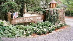
- Follow CR 89/CR 165 for 1 mile and turn right just after crossing the bridge at the ‘Alpine Camp for Boys’ sign, onto the gravel road, CR 624. Continue until the road forks. Bear right at the fork. This will take you through the camp gate. Follow the road until you see the sign for the office.

From Birmingham, Alabama
About 1½ Hours
- Follow I-59 North to Fort Payne, Alabama. Take the first Fort Payne exit (#218) and turn right onto Alabama Highway 35.
- Follow Highway 35 through Fort Payne. Follow signs toward DeSoto State Park. Continue on Highway 35 to the crest of Lookout Mountain.
- As you reach the crest of the mountain, there will be a flashing yellow light. Take a left at the flashing yellow light onto County Road 89 (Desoto Parkway), following signs to DeSoto State Park. Follow County Road 89 through DeSoto State Park to the stop sign (about 6 miles). This will be a “T” intersection.
- Turn right at stop sign and follow CR 165 across the river. Turn right just after crossing the bridge at the ‘Alpine Camp for Boys’ sign, onto the gravel road, CR 624. Continue until the road forks. Bear right at the fork. This will take you through the camp gate. Follow the road until you see the sign for the office.

From Atlanta, GA
About 2½ HOURS
- Take I-75 North to Exit 306, the Adairsville, GA exit. Turn left onto GA 140. Continue on GA 140 until you come to a “T” intersection.
- Turn right onto US 27. Follow US 27 to Summerville, GA. In Summerville take a left onto GA 48. Follow GA 48 through Menlo and up the mountain. Continuing on GA 48 you will cross the state line. GA 48 will become AL Hwy 117. Follow AL 117 into Mentone.
- Turn LEFT onto E RIVER RD/CR-165/County Road (CR) 177. Turn LEFT to stay on CR 177/E River Road. Turn RIGHT to stay on CR 177. Turn RIGHT onto County Road (CR) 106. CR 106 becomes County Road (CR) 165. Continue on CR 165. You will be on this road (CR 106/165) for approximately 4 miles total.
- Turn LEFT on County Road (CR) 624 (You will see the ALPINE CAMP sign on your LEFT).
- Follow the gravel road into ALPINE CAMP FOR BOYS. Continue until the road forks. Bear right at the fork. This will take you through the camp gate. Follow the road until you see the sign for the office.
